About 80% of the geographic area of Meghalaya is covered by forests and tree cover. Meghalaya is a part of the Indo- Myanmar global biodiversity hotspot and home to diverse plant and animal groups. A study was carried out at the request of the state government to assess the current state of the forests and biodiversity and the likely impact of climate change. We assessed the structure (tree count, carbon stock, basal area, and canopy cover), and composition (tree biodiversity) of the forests using data from around 200 plots spread all across the state. We assessed the changes, from 2000 to 2016, in the structure of the forests using high-resolution satellite data supported by ground verification. We modelled the future impact of climate change on vegetation by using high resolution downscaled climate data and a dynamic vegetation model. In total we created 24 new GIS layers of information for the forests.
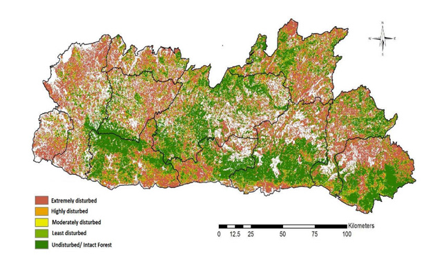
Figure 1 shows the change in Normalised Difference Vegetation Index (NDVI) over 16 years (2000 to 2016) within the forest boundary. It shows that about 50% of the forests in Meghalaya, especially in the north and west Garo hills, have experienced increased disturbance (negative NDVI).
Our field-based analysis suggests an average carbon density of about 55 tonnes carbon per hectare (tC/ha) in the state, which is much higher than the estimates published by forest survey of India (17 tC/ ha). The species richness in our sample plots showed wide variation from single species per plot in degraded forests to almost 30 species per plot in highly dense evergreen forests. Richness of species in the forests is estimated to be high in West Garo hills and parts of Jaintia Hills, and low in districts of West Khasi Hills and Ri- Bhoi.
The vulnerability of the Meghalaya forests was identified using the methodology proposed by IPCC, 2013. Our inherent vulnerability index suggests that currently about 25% of the total forested area in Meghalaya has high or very high vulnerability. About 64% of the forested area in the state is estimated to have low inherent vulnerability, indicating higher resilience in these areas and making them suitable for forest conservation related activities. Forests of North Garo Hills and Ri-Bhoi are the districts with most vulnerable forests in the state, while the forests in East Jaintia Hills and East Khasi Hills are the most resilient.
In this report we conclude that a promising way to protect forests from the effects of future climate is to make them more resilient to the stresses of today’s climate.
Thus we argue that inherent vulnerability should be given preference in planning current adaptation policies in the state. We further argue that strengthening the structure and composition of forests, and augmenting the biodiversity in the state, will not only manage current vulnerabilities and weaknesses of the forest systems in the state but at the same time will also make these forests more resilient to future climatic stresses. We also recommend that the impact and vulnerability information must be used in the forest working plans and in planning of afforestation programmes in the state. Reference: Chaturvedi, RK; Ravindranath N.H et al (2017) Vulnerability of the Forests and Biodiversity of Meghalaya to Climate Change. Report Submitted to the Government of Meghalaya.